
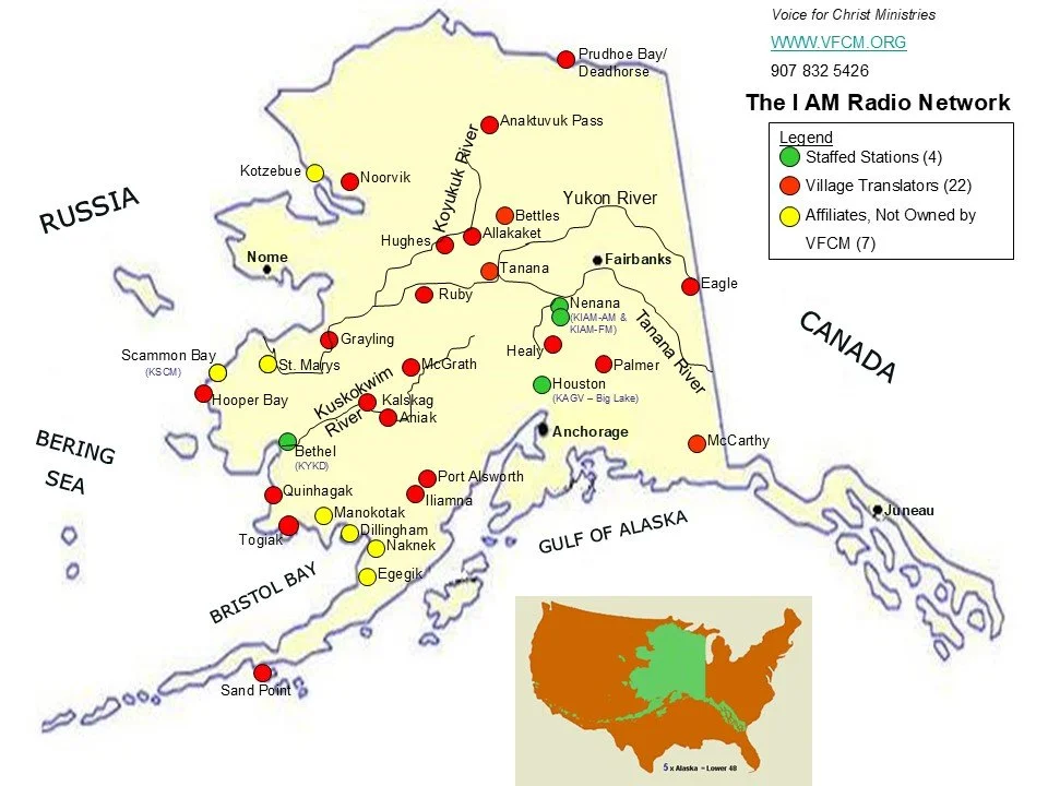
Remote Village Radio
Broadcasting to Remote Villages Across the State
Via Translators and Class D Stations
Village Name: Allakaket
Status: Installed 04/23/07
Location Description: Allakaket is on the south bank of the Koyukuk River, southwest of its junction with the Alatna River, approximately 190 air miles northwest of Fairbanks and 57 miles upriver from Hughes. The village of Alatna is located directly across the river. The community lies at approximately 66.562610° North Latitude and -152.647560° (West) Longitude. The area encompasses 3.6 sq. miles of land and 0.7 sq. miles of water.
Village Name: Ambler - The Ambler translator relocated to Noorvik in the Fall of 2021…
Status: Installed 08/29/07. Decommissioned in September, 2021. License moved to Noorvik, Alaska.
Location Description: Ambler is located on the north bank of the Kobuk River, near the confluence of the Ambler and the Kobuk Rivers. It lies 45 miles north of the Arctic Circle. It is 138 miles northeast of Kotzebue, 30 miles northwest of Kobuk and 30 miles downriver from Shungnak. The community lies at approximately 67.086110° North Latitude and -157.851390° (West) Longitude. The area encompasses 9.5 sq. miles of land and 1.3 sq. miles of water.
Village Name: Aniak
Translator Status: Voice for Chirst Ministries submitted an application to construct a translator station in Aniak in March of 2003. Final approval of that application was not granted by the Federal Communications Commission until November, 2013. The station was originally intended to be a satellite-fed repeater for the I-AM network's flagship station, KIAM. The arrival of high-speed internet service in the village made it technically possible to instead rebroadcast the programming of KYKD in Bethel, a station much more geographically and culturally related to Aniak than KIAM in Nenana, some 400 miles away in the central-interior of the state. In Febuary of 2014 special donations provided sufficient resources to purchase the required equipment and the Aniak Community Church agreed to host the station. Construction was completed on April 25th, 2014, when K232ER began broadcasting on 94.3 MHz.
Location: Aniak is located on the south bank of the Kuskokwim River at the head of Aniak Slough, 59 miles southeast of Russian Mission in the Yukon-Kuskokwim Delta. It lies 92 air miles northeast of Bethel and 317 miles west of Anchorage. The approximate geographic location of the village is 61.58° north latitude and 159.52° west longitude.
Village Name: Anaktuvuk Pass
Status: Installed 08/28/07
Location Description: Anaktuvuk Pass, at 2,200 feet elevation on the divide between the Anaktuvuk and John Rivers in the central Brooks Range, is the last remaining settlement of the Nunamiut (inland northern Inupiat Eskimo). The community lies at approximately 68.143330° North Latitude and -151.735830° (West) Longitude. The area encompasses 4.8 sq. miles of land and 0.1 sq. miles of water.
Village Name: Bettles
Status: Installed
Location Description: Bettles is located about 180 air miles and 250 road miles northwest of Fairbanks, adjacent to Evansville. It lies just north of the Kanuti National Wildlife Refuge. Bettles is located on the S.E. bank of the Koyukuk River. The community lies at approximately 66.917880° North Latitude and -151.515130° (West) Longitude. (Sec. 16, T024N, R019W, Fairbanks Meridian.) Bettles is located in the Fairbanks Recording District. The area encompasses 1.6 sq. miles of land and 0.0 sq. miles of water.
Village Name: Eagle
Status: Installed 05/11/07
Location Description: The City of Eagle and Eagle Village are located on the Taylor Highway, 6 miles west of the Alaska-Canadian border. Eagle is on the left bank of the Yukon River at the mouth of Mission Creek. The Yukon-Charley Rivers National Preserve is northwest of the area. The community lies at approximately 64.788060° North Latitude and -141.200000° (West) Longitude. The area encompasses 1.0 sq. miles of land and 0.0 sq. miles of water.
Village Name: Grayling
Status: Installed 07/26/07
Location Description: As a satellite fed translator station in the northern portion of the village. Unfortunately, the view of the satellite was marginal at that location and about 2011 the growth of trees on the ridge in front of the dish and some other factors resulted in reliability problems for the station. In June of 2016 the station was relocated to the central part of the village and converted to an internet feed from KIAM. There were some equipment reliability problems over the next few months, but by January of 2017 the station was regarded as one of the most reliable in the network. It is the first translator station to be fed via internet from KIAM.
Village Name: Hooper Bay
Translator Status: The translator station in this village, K232DS, was initially installed on July 24th, 2007. In August of 2013 the station was converted to carry the broadcast of KYKD, Bethel, a station much more geographically and culturally linked to this community than KIAM in the interior of the state, the primary station for most of the rest of the network. Unlike most other I-AM network translator stations which are fed via satellite, K232DS is now fed the KYKD audio stream via high speed internet from Bethel. This allowed Hooper Bay to become the first of several regional translator sites associated with KYKD.
Location: Hooper Bay is located 20 miles south of Cape Romanzof, 25 miles south of Scammon Bay in the Yukon-Kuskokwim Delta. The city is separated into two sections: a heavily built-up townsite located on gently rolling hills, and a newer section in the lowlands. Hooper Bay is located 500 miles west of Anchorage and about 150 miles west-northwest of Bethel. The community lies at approximately 61.5° North Latitude and 166.1° West Longitude. The official area of the village encompasses 8.7 sq. miles of land and 0.1 sq. miles of water. Hooper Bay is one of the most westerly villages on the mainland of Alaska. Thus K232DS is one of the most westerly radio stations on the continent. Worldwide, only a handful of stations are any farther west.
Village Name: Hughes
Status: Installed 04/23/07
Location Description: Hughes is located on a 500-foot bluff on the east bank of the Koyukuk River, about 115 air miles northeast of Galena and 210 air miles northwest of Fairbanks. The community lies at approximately 66.048890° North Latitude and -154.255560° (West) Longitude. The area encompasses 3.1 sq. miles of land and 0.0 sq. miles of water.
Village Name: Kalskag
Translator Status: Voice for Christ Ministries submitted an application for a Kalskag translator station to the Federal Communication Commission in March of 2003, but the final approval of that application was not granted until November 4, 2013, over ten years later. The station was then planned for construction during the 2015 summer season, but resources unexpectedly became available in 2014. The Calvary Mission Church in Upper Kalskag agreed to host the station and required equipment was procured in June and July. It was necessary to obtain a minor change in broadcast frequency from 94.3 MHz to 93.7 MHz in order to avoid conflict with the recentlly constructed Aniak station. As a result of that change the FCC changed the station designation from K232EU to K229CV. The actual construction of the station was completed on August 21st, 2014. K229CV is the very first FM station of any type to be heard in the villages of Kalskag. We praise God for His provision to allow this station to begin broadcasting His message to the people He loves in these villages in His perfect timing.
Location:Upper Kalskag is located on the north bank of the Kuskokwim River, 26 miles west of Aniak, 89 miles northeast of Bethel, and 348 miles west of Anchorage. The geographic location is 61.5377 degrees north latitude and 160.3072 degrees west longitude. Lower Kalskag is located on the north bank of the uskokwim River, 2 miles downriver from Upper Kalskag.
Village Name: McCarthy
Status: Installed 10/19/05
Location Description: McCarthy lies 61 miles east of Chitina off the Edgerton Highway. It is on the Kennicott River at the mouth of McCarthy Creek, 12 miles northeast of the junction of the Nizina and Chitina Rivers, in the heart of the Wrangell-St. Elias National Park and Preserve. The community lies at approximately 61.433330° North Latitude and -142.921670° (West) Longitude. McCarthy is located in the Chitina Recording District. The area encompasses 148.3 sq. miles of land and 0.0 sq. miles of water.
Village Name: McGrath
Status: Installed
Location Description: McGrath is located 221 miles northwest of Anchorage and 269 miles southwest of Fairbanks in Interior Alaska. It is adjacent to the Kuskokwim River directly south of its confluence with the Takotna River. The community lies at approximately 62.956390° North Latitude and -155.595830° (West) Longitude. (Sec. 18, T033N, R033W, Seward Meridian.) The area encompasses 48.9 sq. miles of land and 5.7 sq. miles of water.
Village Name: Prudhoe Bay
Status: Installed 06/14/07
Location Description: Prudhoe Bay lies offshore in the Beaufort Sea, east of Nuiqsut, in the northern waters of Alaska. The community lies at approximately 70.255280° North Latitude and -148.337220° (West) Longitude. (Sec. 08, T010N, R015E, Umiat Meridian.) Prudhoe Bay is located in the Barrow Recording District. The area encompasses 416.3 sq. miles of land and 141.8 sq. miles of water.
Village Name: Quinhagak
Translator Status: The station was originally installed on July 25th, 2007, as a satellite-fed translator repeater for KIAM in Nenana. In 2014 the resources became available to convert the station to retransmit KYKD in Bethel, a station much more geographically and culturally connected to Quinhagak than KIAM, some 500 miles away in the interior of Alaska. During February, tests indicated that the KYKD signal could be received adequately off the air using a high-gain directional antenna. Unfortunately, in June when the conversion was attempted, the signal was no longer strong enough to use, apparently because of the seasonal shift to summer atmospheric conditions. The conversion was finally completed on August 19th, 2014, when the KYKD team installed powerful signal filtering and amplification equipment. K232DW now receives the KYKD signal directly from Bethel at 100.1 MHz and "translates" it to 94.3 MHz for rebroadcast to the village and surrounding area.
Location: Quinhagak is on the Kanektok River on the east shore of Kuskokwim Bay, less than a mile from the Bering Sea coast. It is 71 miles south-southwest of Bethel. The community lies at approximately 59.75° North Latitude and 161.92° West Longitude.
Village Name: Ruby
Status: Installed
Location Description: Ruby is located on the south bank of the Yukon River, in the Kilbuck-Kuskokwim Mountains. It is about 50 air miles east of Galena and 230 air miles west of Fairbanks. Ruby lies adjacent to the Nowitna National Wildlife Refuge. The community lies at approximately 64.739440° North Latitude and -155.486940° (West) Longitude. (Sec. 04, T009S, R017E, Kateel River Meridian.) Ruby is located in the Nulato Recording District. The area encompasses 7.6 sq. miles of land and 0.0 sq. miles of water.
Village Name: Sand Point
Status: Installed
Location Description: Sand Point is located on Humboldt Harbor on Popof Island, off the Alaska Peninsula, 570 air miles from Anchorage. The community lies at approximately 55.339720° North Latitude and -160.497220° (West) Longitude. The area encompasses 7.8 sq. miles of land and 21.1 sq. miles of water.
Village Name: Tanana
Status: Installed
Location Description: Tanana is located in Interior Alaska about two miles west of the junction of the Tanana and Yukon Rivers, 130 air miles west of Fairbanks. The community lies at approximately 65.171940° North Latitude and -152.078890° (West) Longitude. (Sec. 17, T004N, R022W, Fairbanks Meridian.) Tanana is located in the Ft. Gibbon Recording District. The area encompasses 11.6 sq. miles of land and 4.0 sq. miles of water.
Spreading the Love of Jesus across Alaska
— VFCM